Overview
The North Atlantic Waveguide, Dry Intrusion, and Downstream Impact Campaign (NAWDIC) is a new initiative for an international field campaign focusing on mid-latitude atmospheric dynamics with the aim to provide detailed observations for improving the understanding and modelling of the mesoscale tropopause structure, the dry intrusion air stream – planetary boundary layer (PBL) interaction, and their relation to high impact weather (HIW) in the North Atlantic region in winter. NAWDIC will build directly on insights of the North Atlantic Wave guide and Downstream impact EXperiment (NAWDEX; Schäfler et al. 2018; http://nawdex.org) that observed diabatic processes in ascending air streams and investigated their impact on the tropopause structure. NAWDIC is initiated through its German HALO-aircraft component, currently scheduled for January/February 2026, However, NAWDIC has now grown to an international campaign, consisting of several components, which are planned as stand-alone measurement campaigns by different groups, but will benefit from synergies if coordinated under the umbrella of NAWDIC.
NAWDIC is officially endorsed by the World Weather Research Programme (WWRP) of the World Meteorological Organization (WMO).
Scientific Goals
NAWDIC aims to advance our understanding of the synoptic- to micro-scale dynamical and physical processes associated with the triggering of severe wind gusts, heavy precipitation, and cold air outbreaks in the North Atlantic, Euro-Mediterranean region and of their representation in NWP models. More specifically, NAWDIC will focus on the physical understanding and quantification of the dry intrusion airstream for the evolution of HIW related to extratropical cyclones in winter. NAWDIC research is structured around three science goals:
- NAWDIC will make measurements able to characterize the mesoscale structure of the cloud and wind field, including vertical motion, within the jet stream, particularly near jet streaks and in locations where the coherent descent of dry intrusion air masses begins.
- NAWDIC will strengthen our understanding of momentum transport into the PBL and its role in the formation of severe wind gusts and convection. This will be achieved by high-resolution observations of wind, temperature, all phases of water, and cloud microphysical properties where dry intrusions descend to the top of the PBL, the PBL and surface beneath as well as the neighboring cold fronts.
- NAWDIC will clarify the importance of the model representation of surface fluxes in the cold sector and near fronts of extratropical cyclones for HIW and subsequent cyclogenesis, in particular over the ocean. To this end, detailed observations of turbulent heat, moisture and momentum fluxes at the air-sea interface are planned.
Scientific Background
The tropopause structure is important for the extratropical large-scale circulation, as it is closely related to the strength of the jet stream, forming a wave guide for Rossby waves (e.g. Martius et al. 2010; Grams and Archambault 2016; Quinting and Vitart 2019). Two of the key findings of NAWDEX are (i) previously unobserved near-tropopause mesoscale perturbations related to diabatic processes that sharpen the tropopause potential vorticity gradient and enhance the jet stream wind speeds (Harvey et al. 2020; Oertel et al. 2020), and (ii) observational evidence of an underestimation of humidity, temperature and wind gradients at the tropopause already in the analysis and early forecast of state-of-the-art NWP systems (Schäfler et al. 2020).
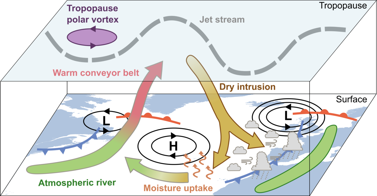
The tropopause structure may affect the formation of HIW in two ways: either through the remote influence of tropopause perturbations on the large-scale balanced flow or through direct descent of air masses from upper to lower levels. A key feature in the air mass transport context is the dry intrusion airstream, which connects the near-tropopause air with weather phenomena at the surface downstream in a Lagrangian sense. Within DIs, air masses descend slantwise from near the tropopause towards the cold front of the cyclone downstream (Browning 1997), where they are climatologically associated with enhanced vertical mixing in the boundary layer and heavy frontal precipitation (Raveh-Rubin 2017; Catto and Raveh-Rubin 2019). Yet, there are still major uncertainties regarding the dynamics of perturbations along cold fronts, such as cold frontal rainbands and their relation to severe weather. Further, when DIs reach the planetary boundary layer the presence of relatively cool and dry air over the ocean enhances moisture uptake (Ilotoviz et al. 2021; Givon et al. 2024). This could support the formation of or interaction with atmospheric rivers, which frequently lead to widespread heavy precipitation, particularly when encountering orography.
Observational Strategy
We envision NAWDIC as a modular international effort, in which several groups contribute components that are in principle feasible as stand-alone projects. This gives us the necessary flexibility to cope with unavoidable uncertainties in funding, planning, and implementation. NAWDIC forms the umbrella aiming to realize all components together in a coordinated manner in order to maximize synergies between the individual contributions. NAWDIC follows a “seamless” observational approach across scales: high-altitude, long-range aircraft, such as HALO, will characterize the large-scale environment and provide observations with remote sensing and dropsondes covering the spatial extent of a synoptic event. Envisaged observations with mid-range, mid-troposphere aircraft (e.g., French ATR42; German TUBS Cessna F406) components will characterize the mesoscale structure and cloud microphysical properties of the descending dry intrusion airstream and the PBL. This will be complemented with ground-based measurement networks that are high resolution in both time and space to observe the mesoscale and convective structures connected to surface weather impact. In our seamless approach, modelling forms an integral part, which will – in collaboration with weather services – directly transfer the heterogeneous but precise observations into a structured model using data assimilation systems across scales.
For more details we refer to the International Science Plan.


