Atmospheric River Reconnaissance (AR Recon)

Atmospheric rivers (ARs), long narrow bands of concentrated water vapor transport, are the primary drivers of both hazardous flooding and beneficial water supply in the western United States. Initiatives developed to improve predictions of ARs and their hydrologic impacts are motivated by the pressing need for support for water resource and emergency management.
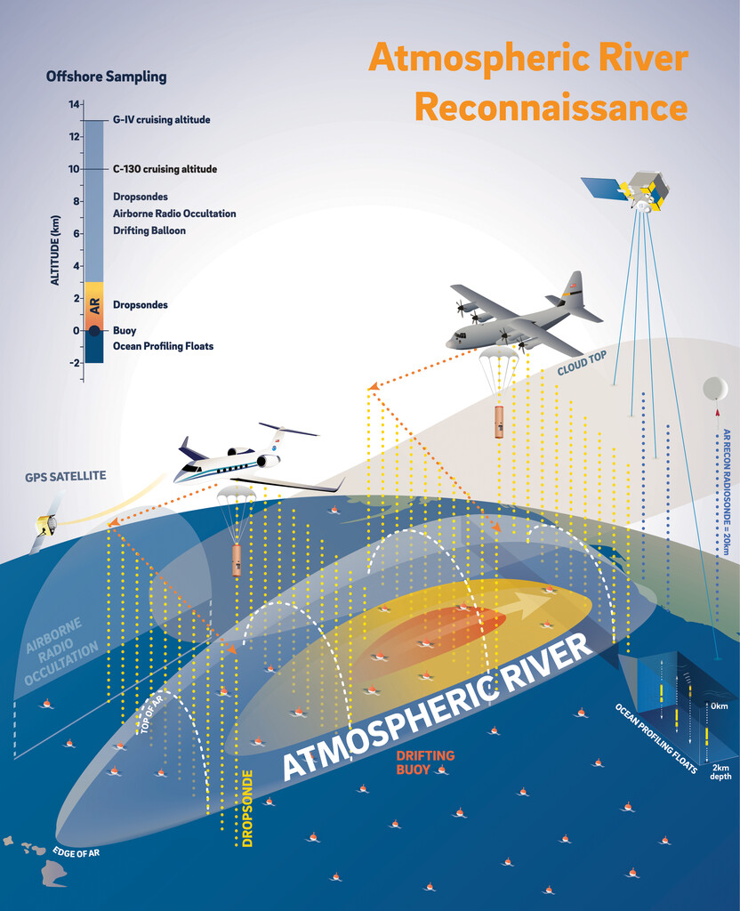
Created by the Center for Western Weather and Water Extremes (CW3E), Atmospheric River Reconnaissance (AR Recon) is a Research and Operations Partnership (RAOP) with NOAA National Center for Environmental Prediction (NCEP) that employs U.S. Air Force Reserve Command 53rd Weather Reconnaissance Squadron and NOAA aircraft, along with other data collection methods (Fig. 1, Lavers et al., 2024), to fill critical data gaps needed to improve forecasts of landfalling ARs affecting the U.S. West Coast (Ralph et al., 2020).
To accomplish this, the AR Recon RAOP has built a robust, international network of experts from government, academia, and industry to assemble a U.S. weather reconnaissance capability that actively monitors, predicts and studies ARs in the North Pacific. These campaigns improve forecast skill in real time through direct assimilation of the observations in forecast models during the storms. Also, the research component of AR Recon works to improve the weather model itself and develop new measurements as well as novel data assimilation and verification methods, which improve forecast skill over the long term. Results to date, published as part of AR Recon’s research efforts covering multiple years and individual cases, show that these data can improve precipitation forecasts substantially.
The North American cold season operational period runs for five months, from November 1st through March 31st. Operational flight sampling missions are primarily based out of California and Hawaii, but have included flights based out of Guam, Alaska, Utah, Oregon, Washington, Nevada, and Mississippi.
Platforms and Capabilities
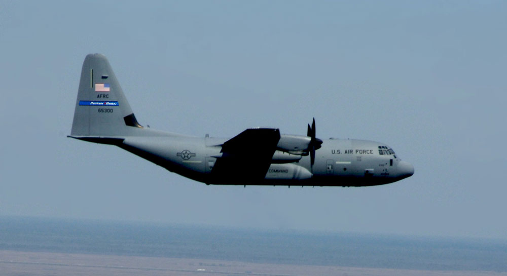
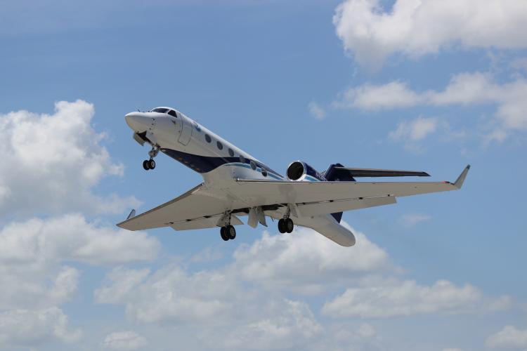
Aircraft: Both the WC-130J Hercules (Fig. 2) and NOAA G-IV (Fig. 3) are configured with weather instrumentation for monitoring of ARs to obtain data on system movement, size, and intensity. Onboard equipment analyzes atmospheric conditions such as pressure, temperature, dew point and wind speed. This data is sent in real time via satellite link for incorporation into global weather models.
Dropsonde System: The dropsonde is equipped with a high frequency radio and dropped within and around the AR, as the instrument descends to the sea surface, it measures and relays to the aircraft a vertical atmospheric profile of the temperature, humidity, barometric pressure, and wind data. The dropsonde is slowed and stabilized by a small parachute. Onboard the C-130, the Dropsonde System Operator receives, analyzes, and encodes the data for transmission via satellite.
Airborne Radio Occultation (ARO): ARO data provide complementary profiles to the dropsonde information using GPS satellites and a specially designed receiver, collecting data from which temperature and moisture can be extracted. Profiles are slanted away from the aircraft flight path, with the lowest points providing information as far as 400 km away.
Tail Doppler Radar (TDR): TDR mounted to the rear of the G-IV is an 8,000 watt radar system that spins slowly as the aircraft passes by the storm and looks at the structure using radar to determine the storm intensity. The images collected by the TDR allow forecasters and researchers to see the different layers of a storm, which help improve forecasting capabilities.
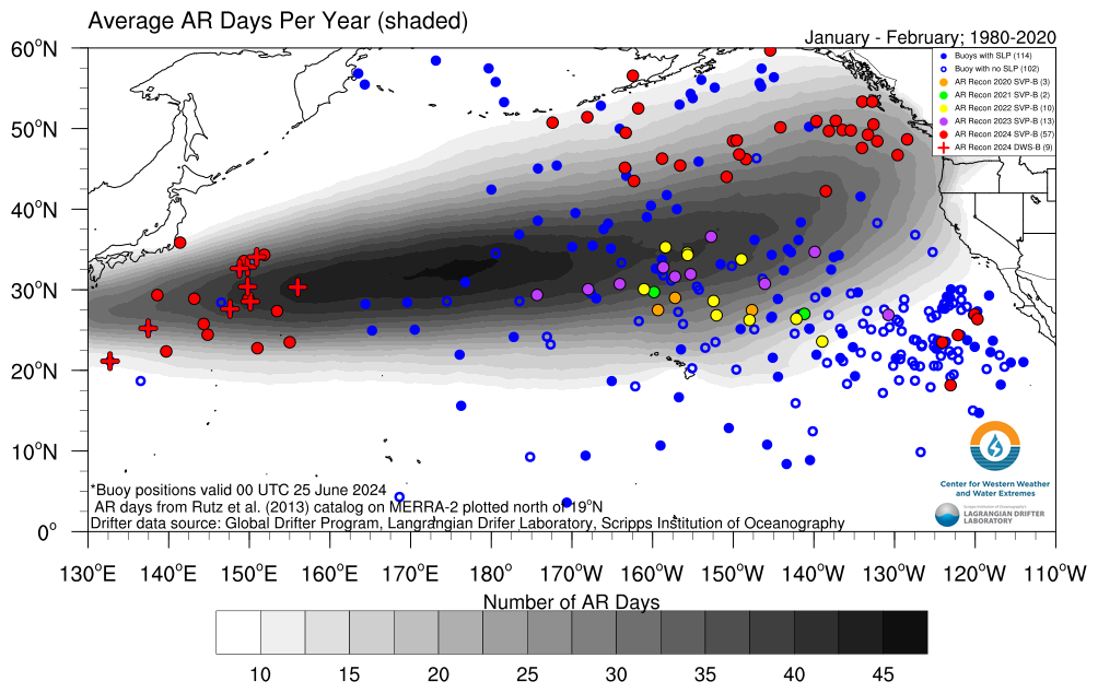
Drifters: In collaboration with the NOAA-funded Scripps Institution of Oceanography’s Global Drifter Program, satellite tracked drifters with barometers to measure atmospheric pressure at the ocean’s surface are deployed in the North Pacific in conjunction with the start of the AR Recon Season. These buoys target North Pacific regions that experience the highest number of AR days per year. They are either Directional Wave Spectra-Barometer (DWS-B) drifting buoys or Surface Velocity Program - Barometer (SVP-B) drifting buoys. Both types of drifters provide the same data on sea surface temperature and sea level pressure, but the DWS-B are un-drogued and provide information on wave spectra while the drogued SVP-B drifters measure near-surface ocean currents at a depth of 15 m. These buoys provide vital sea-level pressure, water temperature and wave measurements from a region lacking data needed for numerical weather predictions and climate studies.
Radiosondes: CW3E’s radiosonde launch stations are positioned across various watersheds in the western United States to support Forecast Informed Reservoir Operations (FIRO). These stations play a crucial role in studying the development and intensity of ARs making landfall in the U.S. West Coast. During storm events, CW3E attaches radiosondes to weather balloons to collect observations of pressure, temperature, wind speed and direction, and humidity as the weather balloon ascends into the atmosphere to a height of approximately 25,000 meters (82,000 ft). The radiosondes are launched every three hours during storm conditions, but can be more frequent during periods of high interest. The data are sent to the Global Telecommunications System and are available for assimilation into operational global weather models.
Global Sounding Balloons: WindBorne Systems designs, manufactures, and operates an artificial intelligence-enabled, highly sustainable, long-duration global sounding balloon (GSB) that collects atmospheric observations from 1 km to 15 km above the earth’s surface. The GSB measures the same data points as a traditional weather balloon but can remain aloft for weeks on end and reach far remote locations as it travels throughout the world along wind trajectories. During flight, GSBs are often directed to repeatedly ascend and descend to collect vertical profiles of atmospheric data between 1 and 15 km above the earth’s surface. Up to 40 vertical profiles of data are collected per flight, at an efficiency of up to 150x more data per cost dollar compared to traditional weather balloons. WindBorne launches 100+ balloons per month from a growing number of launch sites across three continents: North America, Asia, and Africa. All of WindBorne’s technology, spanning its balloon platform, to flight autonomy software and AI-based forecasts are invented and built in California.
Coordinated Observations during NAWDIC
The AR Recon RAOP intends to extend reconnaissance flights into the Gulf of Mexico and the Western North Atlantic in winter 2025/2026 which would complement the research goals of NAWDIC. Observations of ARs in these two regions are expected to improve predictions of cyclones and warm conveyor belts near the U.S. east coast, which in turn affect the amplification of downstream ridges and the structure of the upper troposphere in the dry intrusion (DI) inflow region. Coordinated flights of AR Recon and the HALO research aircraft during NAWDIC will help to link upstream moisture sources over the Western Atlantic with upper-tropospheric DI formation and downstream high-impact weather over Europe for the first time.
Contact: Marty Ralph (CW3E), Anna Wilson (CW3E), Vijay Tallapragada (NOAA/NCEP/Environmental Modeling Center)