
NAWDIC-HALO
Accurately forecasting the location, timing, and intensity of mesoscale high impact weather (HIW) events remains a challenge for state-of-the-art numerical weather prediction (NWP) models. This is to a large degree due to the multi-scale interactions of physical processes involved in the formation of HIW, ranging from upper-tropospheric Rossby waves covering several thousands of kilometers and lasting several days, to momentum transport in the planetary boundary layer (PBL) and cloud microphysics acting on scales of hundreds of meters to micrometers and minutes to seconds. A key feature that connects upper-tropospheric Rossby waves in remote regions with HIW in Europe is the dry intrusion (DI) airstream (Carlson 1980, Browning 1997). During winter months, DIs emerge most frequently from the downstream flank of upper-tropospheric ridges over eastern North America. From this region, DIs descend equatorward in the cold sector of a downstream cyclone over a horizontal distance of 1000 to 5000 km and reach the PBL about 2 days later. The DI outflow is accompanied by intense surface heat and moisture fluxes, elevated PBL heights and a destabilization of the lower troposphere leading to unusually strong wind gusts and extreme rainfall at the surface (Raveh-Rubin 2017). The DI thus constitutes a multiscale weather system that often involves HIW.
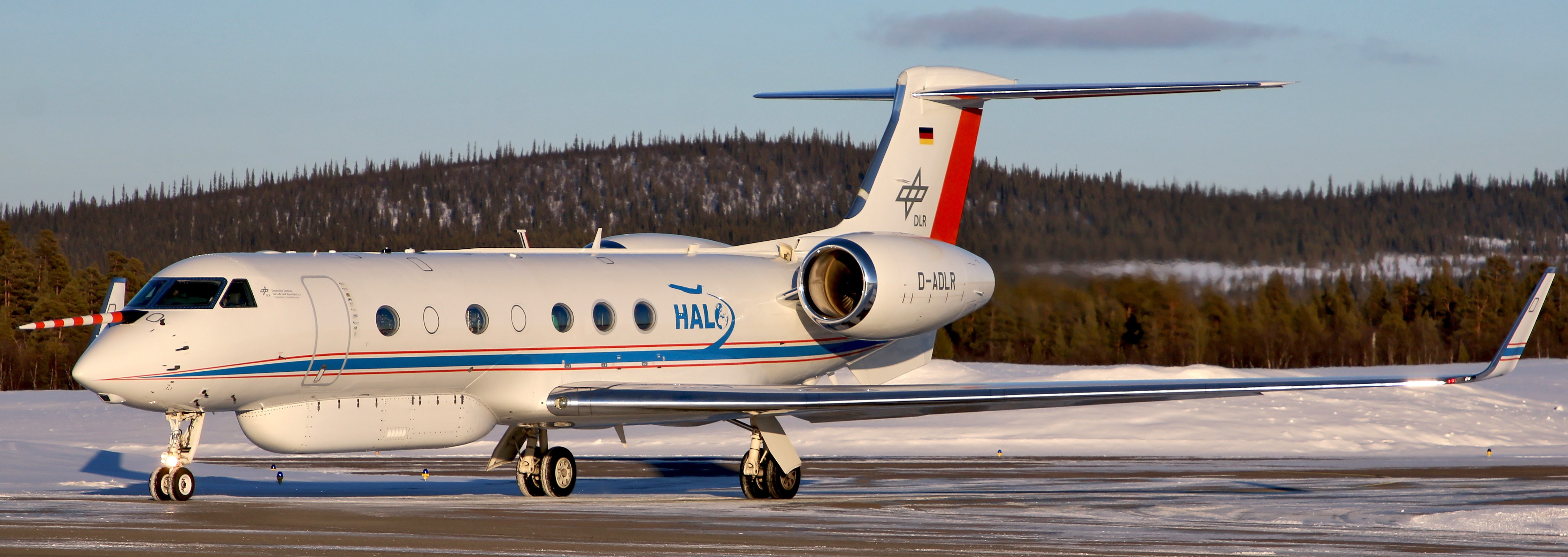
Most of the time, the involved multiscale processes relevant to HIW in Europe occur upstream over the Atlantic Ocean and are insufficiently captured by operational observing systems. Accordingly, modern measurement systems on long-range research aircraft are the only way to obtain reliable observations with the necessary high spatial and temporal resolution in these remote regions. Therefore, the high-altitude and long-range research aircraft HALO (Fig. 1) operated by the German Aerospace Center (DLR) was chosen as the key component of NAWDIC. With its long range and advanced instrumentation, HALO allows to perform multiple consecutive flights over several days to sample the processes at two distinct stages of the DI lifecycle.
The core measurement period of HALO for NAWDIC is scheduled for 6 weeks from 12 January to 20 February 2026 with operation base at Shannon Airport (Ireland). A novel payload combining remote sensing observations with in-situ trace gas measurements will yield a comprehensive picture of the thermodynamic fields from the lower stratosphere to the PBL and transport and mixing processes in the DI airstream:
- WALES (DLR): four-wavelength differential absorption lidar
- HEDWIG (DLR): newly-developed airborne Doppler wind lidar
- KITsonde (KIT): modular multi-sensor dropsonde system
- specMACS (LMU Munich): imaging cloud spectrometer for the solar spectral range
- UMAQS (JGU Mainz): quantum cascade laser spectrometer for trace gas measurements
- FISH (FZ Jülich): fast in-situ stratospheric hygrometer
- FAIRO (KIT): ozone detector
- BAHAMAS (DLR): basic HALO measurement and sensor system
NAWDIC measurements will allow a targeted evaluation of the quality of operational observing and analysis systems in regions crucial for HIW. Additionally, NAWDIC will provide detailed knowledge of the physical processes acting in these regions and especially of the mechanisms responsible for errors in the prediction of HIW ultimately leading to a better representation of uncertainty in NWP systems, and better (probabilistic) forecasts.
Contact: Julian Quinting (KIT), Andreas Schäfler (DLR)
Science Projects
NAWDIC-MESO
High-impact weather (HIW), such as extreme surface precipitation and winds, is particularly prevalent during winter in the North Atlantic European region. HIW in extratropical cyclones (ETCs) is related to different atmospheric processes and interactions across various scales. Deep convection embedded in the cold frontal region of ETCs is one of the processes producing HIW and occurs on spatial scales of 10 to 100 km, the so-called mesoscale. The correct representation of mesoscale convective clusters is still one of the challenges in the current numerical weather prediction (NWP) systems. Thus, an improved understanding of processes leading to embedded convection and its mesoscale variability in the near-frontal region is required. An important role in triggering precipitation at the cold front (Raveh-Rubin and Catto 2019) or suppressing the convective activities (Morcrette et al. 2007, Russel et al. 2012) may be related to the dry intrusion (DI) airstream, which is a dry and cold airstream descending from the tropopause to the planetary boundary layer in ETCs.
In order to better understand the involved processes, the project NAWDIC-MESO (The MESOscale thermodynamic structure near cold fronts and its role for embedded convection) aims to improve our understanding of the mesoscale structure of the cold frontal region, the interaction between the DI and the cold front, and its relation to deep convection from both Lagrangian and Eulerian perspectives. To address the research questions, we will make use of the observational data measured during the NAWDIC campaign with the aid of the KITsonde system onboard HALO and KITcube which will provide high-resolution profile measurement of thermodynamic and dynamic properties of the atmosphere during HIW. The observational component will be accompanied by synergistic analysis of operational NWP products as well as by high-resolution numerical modeling.
Contact: Annika Oertel (KIT)
NAWDIC-FLUX
Turbulent fluxes exchange heat, momentum and moisture between the ocean and the atmosphere and, thus, crucially influence the atmospheric and oceanic circulation from weather to climate scales. Despite their importance, these fluxes are rarely observed, and their spatial and temporal distribution remains poorly understood. This uncertainty impacts their parametrized representation in numerical weather prediction (NWP), where they play a crucial role in the predictability of weather, in particular of High Impact Weather (HIW) events, such as storms, heavy precipitation or droughts.
HIW in the midlatitudes is strongly influenced by transient cyclones, which redistribute warm and cold air, drive strong winds and, hence, give rise to turbulent fluxes. Latent heat fluxes (LHFs) in cold sectors of cyclones have an important preconditioning effect, moistening the marine boundary layer (MBL). This moistened air is subsequently advected into newly developing cyclones where it affects latent heating and precipitation processes.
The NAWDIC-FLUX project focusses on airborne lidar observations of latent heat fluxes in extratropical cyclones. Innovative measurements of LHF profiles in the cold sector of cyclones along with a characterization of the MBL will be carried out using combined wind and water vapor lidar observations. The high accuracy and extended spatial coverage of these observations will enable a more accurate evaluation of NWP. In particular, we aim to identify systematic, weather system-relative errors in remote oceanic regions, providing insights for future improvements in observation and analysis systems critical for accurately predicting HIW events.
Contact: Andreas Schäfler (DLR)
ORIGAMI-DI
The measurments during NAWDIC-HALO will allow us to shed new light into the air mass composition in a dry intrusion (DI). In the project ORIGAMI-DI (Air mass origin, transport and mixing associated with dry intrusions), we will use high resolution trace gas mesurements in combination with Lagrangian analysis tools to identify the origin, the transformation and the fate of air masses associated with DIs. Ultimately, we will be able to determine how DIs affect the surface air mass composition.
Contact: Daniel Kunkel (JGU Mainz)
ExTrA
The measurements of the DI lifecycle will directly link to the ERC-StG project ExTrA (Extratropical-Tropical interaction: A unified view on the extratropical impact on the subtropics and tropics at weather timescales), where DIs are the central flow feature linking midlatitude large-scale dynamics with near-surface HIW at lower latitudes.
Contact: Shira Raveh-Rubin (WIS)